It looked like maps of past years
The first maps appeared on Earth almost simultaneously with the appearance of a person drawing skills. However, it was not quite the card, and the prototypes of their distant, but one thing is clear: as soon as people began to move over long distances, he was trying to make sense of their moving and enjoying the natural spatial intuition, trying to show it in pictures. Maps in the more or less usual form appeared much later, but it is also an incredibly long time - even before our era.
The prototype of an ancient map
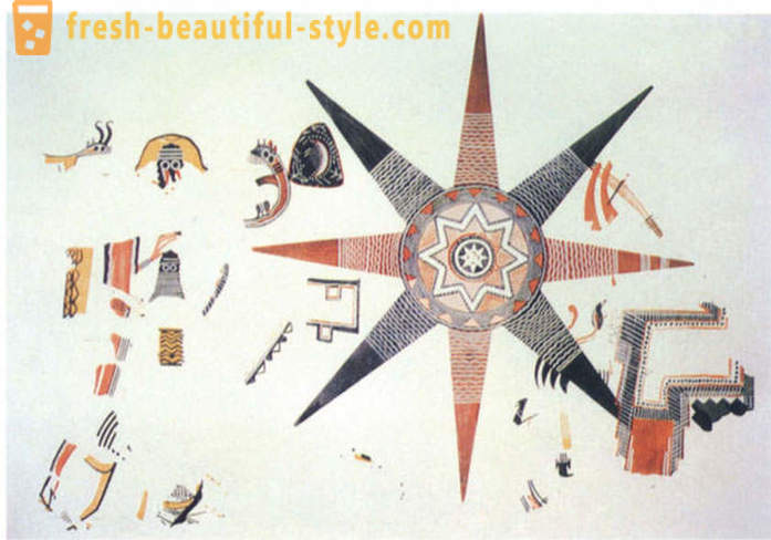
Initially, the "ancestors" card looked like schematic drawings on the walls of caves, houses, ancient utensils (eg plates), stone slabs.
For example, this "star" fresco, found by archaeologists, was created in ancient Jordan and is, according to the scientists, the cosmological map. In the center is "known world", "the first ocean", the "second world" and "the second the ocean." With eight points, which is likely to symbolize the island, located "wordly world" and "the heavenly ocean." A rectangle located at the bottom right, according to historians, is irrelevant - a drawing of a building (probably a temple).
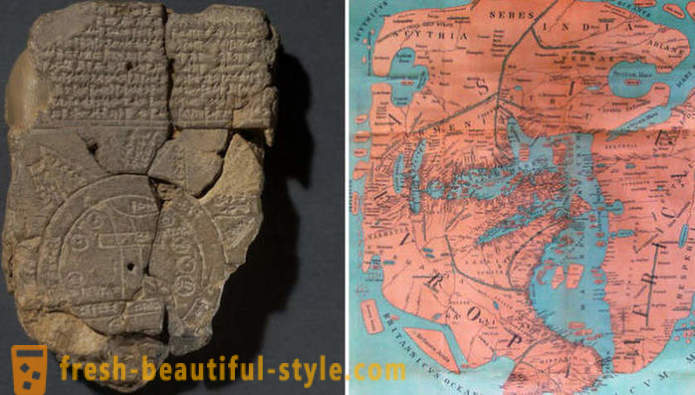
The most ancient map of the world
One of the earliest surviving maps, which are known to scientists, is considered an ancient relic found in Iraq. This card, which received great popularity and influence people's perceptions of the world, was established in Babylon.
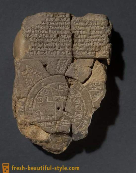
The world it depicts a flat, circular, and its center is marked, as you might guess, Babylon itself. Image found on a piece of pottery plates, dated VII century BC.
Anaximander ahead of its time
A real breakthrough in the field of geography and cartography occurred when there was a map drawn up by Anaximander of Miletus (610 - 540 BC..). Earth he imagined in the form of an oval, which stretches from east to west.
Anaximander, which is respected and considered a great sage Aristotle himself, was not only a geographer, but also an astronomer. He tried to compare the Earth with other space objects, as well as a lot of thinking on the origins of the universe, came to the conclusion that it is born, it reaches its peak, die, and then rises again.
Neither the world map drawn by Anaximander, or a copy thereof to the present day has not been preserved, but Herodotus wrote that the world was on her ancient scholar portrayed in the shape of a drum, around which there is the ocean.
Map of Anaximander, recreated by modern researchers from written sources of ancient scholars. /Foto:wikipedia.org
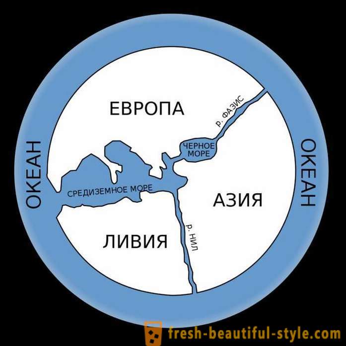
To have survived, and information about the card Hecataeus of Miletus, who lived around the same period, but a little later. According to her, the world is divided into three parts - Europe, Asia and Libya. All three "mainland" are located around the Mediterranean Sea. His map was made on the basis of data of Anaximander.
Very similar painted this view of the world of the priest and lexicographer Isidore of Seville in his "Etymologies" (VII c.). The shape of the letter "T" shows the sea, and the letter "O" represents the ocean. And here it is already Africa.
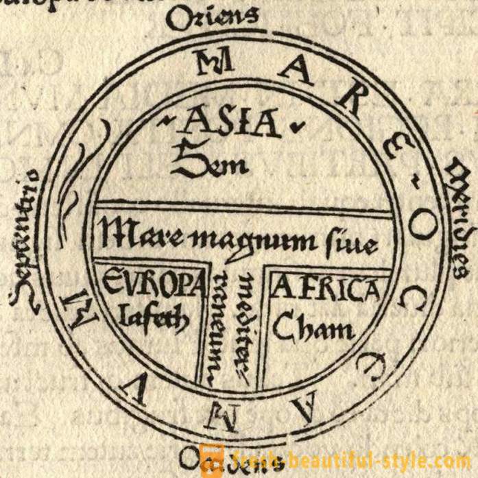
schematically and available: T - the sea, about - the ocean. Historians call this type of card "T-O". /Foto:noosphere.ru/ Father geography (actually, the first and he coined this term) Eratosthenes believe that during II century BC. e. I wrote a three-volume work, which is called - "Geography". It stated that the earth is a sphere, and this claim scientists confirmed their mathematical calculations. Alas, in its original form, this work until the modern scientists have not reached - is known about it from the retelling of the Roman authors. It is also not preserved and Eratosthenes card, but it has had an invaluable impact on the study of geographers of the Middle Ages.
Scientists believe that Eratosthenes card looked like. /Foto:.blogspot.com
By the way, Eratosthenes became the first mark on the meridians maps - though these designations are not as accurate. And yet it was he who divided the world into five climate zones.
The most interesting ancient maps
But this card has created a 400-s BC historian Herodotus:
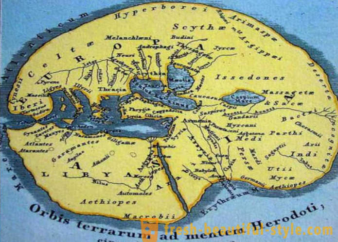
Map of Herodotus. /Foto:livemaster.ru
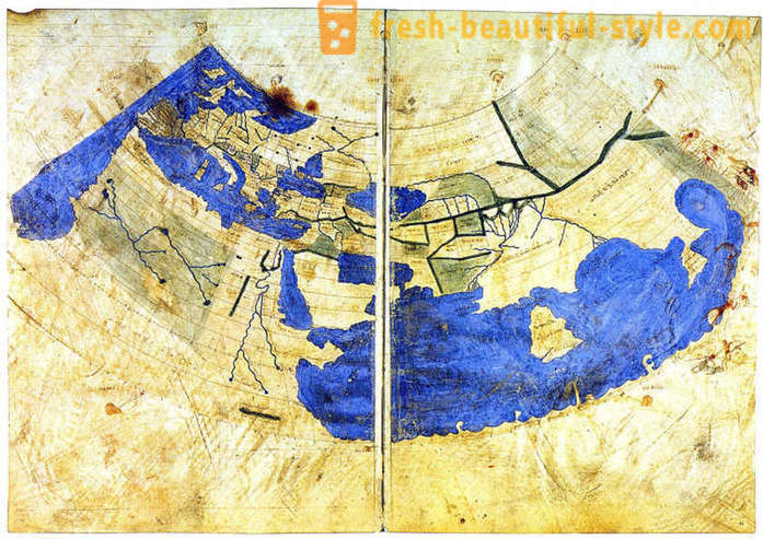
Map Pomponius Mela - the earliest Roman geographer who created the scientific work "Descriptive Geography" - divides the Earth into five zones, three of which are uninhabited. Mel thought that the southern lands of the planet available to northerners, because they are separated from the temperate latitudes dryland unbearable heat.
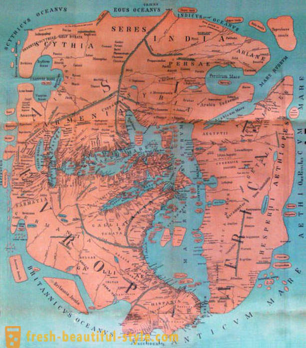
reconstituted by modern researchers map of Pomponius Mela. /Foto:blogspot.com
Like many predecessors, he considered the Caspian Sea bay of the Arctic Ocean. And this is not surprising, because in '43, when Pomponius Mela created his work, most of the planet has not been studied. Another interesting finding, mosaic map discovered in Madaba (Jordan) during archaeological excavations of the early Christian church of St.. George, is an ancient Jerusalem. Panel made approximately VI century. It shows the church and other buildings. They are shown so realistic that even modern scientists were able to identify them - for example, clearly visible in the center of the Holy Sepulcher. According to scientists, it is the oldest map of the Holy Land.
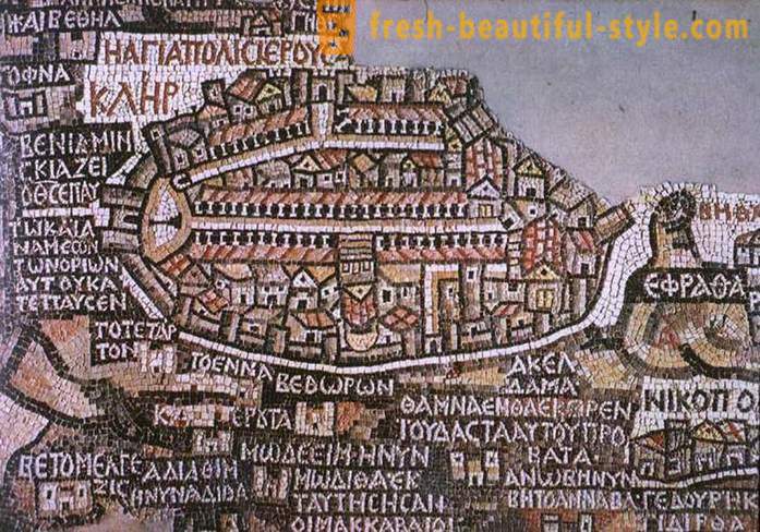
A beautiful and informative mosaic map of Madaba. /Foto:wikipedia.org
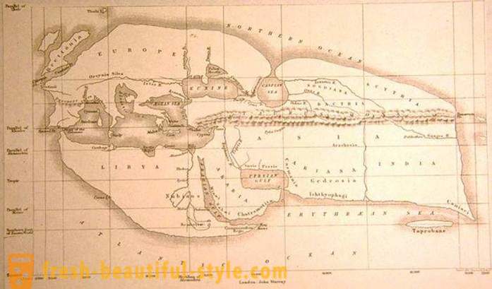
Ptolemy's world map as a guide for the children
Huge work has done a great scholar from Alexandria Claudius Ptolemy. Around 150, he drew a map of the world, which annexed about 30 separate, more detailed maps. The whole treatise called "Guide to Geography".
So Ptolemy saw our world. /Foto:noosphere.ru
Ptolemy marked the location of even the most remote areas - from Egypt and to the Scandinavian lands, and from the Atlantic to Indo-China. This relic was discovered many centuries later and for a long time, until the era of geographical discoveries, was the main cartographic document for travelers and scientists. She was subsequently improved.
Such continents as Asia, Europe and Africa, on the modified map became more decorated, but instead of Babylon as the center of the world was listed Jerusalem.
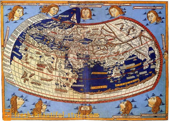
Map "inhabited world" Ptolemy, reconstructed after his death to the Byzantine manuscript of the XIII century - one of the most famous and informative. Ptolemy's map is divided into equal parts by the parallels and meridians. Mediterranean area and the Middle East are represented more or less true, but as the distance to the south are becoming more blurred Ptolemy's knowledge of other lands. For example, the Indian Ocean, he designates as an inland sea, and undiscovered part of the African continent to the south expands and surrounds it by connecting with Asia. Ideas about Antarctica yet - it is "unknown land". Well, Asia, according to him, was so huge that even the occupied territory where, as it turned out, many years later, is the Pacific Ocean.
Recently, the University of Chicago has digitized all the old maps, and published six-volume work on the history of geography and cartography with explanations. This large-scale project on ancient cartography began in the 1980s, and perhaps he will still be updated with new archaeological and historical finds.


- Most popular
-
 The hottest T-shirts: photo ideas
-
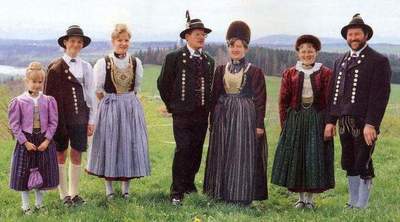 German national costumes for women, men and children. Ethnic garments
-
 Joker Tattoo: symbols and photos
-
 Eyebrows wide. To go wide eyebrows? Fashion for thick eyebrows
-
 Hockey player Wayne Gretzky: biography, personal life, sports career
-
 Beautiful wedding hairstyle "bump" with his own hands. Hairstyle "bump" for each day
-
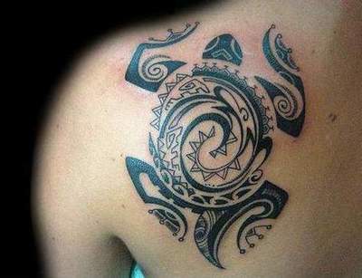 Polynesian tattoos: the meaning of symbols
-
 Round face. Top women's haircuts and hairstyles for round face shapes (photo)
-
 Hairstyles for girls 10 years old in school
-
 Hovercraft. Specifications and photos
-
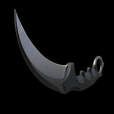 Knife "KARAMBIT": a photo, price, drawings and diagrams. How to make a knife "KARAMBIT" with his own hands?
-
 Making the perfect wedding nails design
-
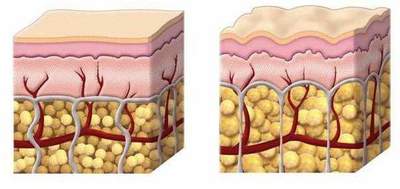 How to get rid of cellulite on legs? Exercises for the legs of cellulite
-
 6 street workout that you can do with a guy
-
 The main rules of Kate Middleton's style